New Features for your Northern Lights Forecast!
The New Features for your Northern Lights Forecast launched today are:
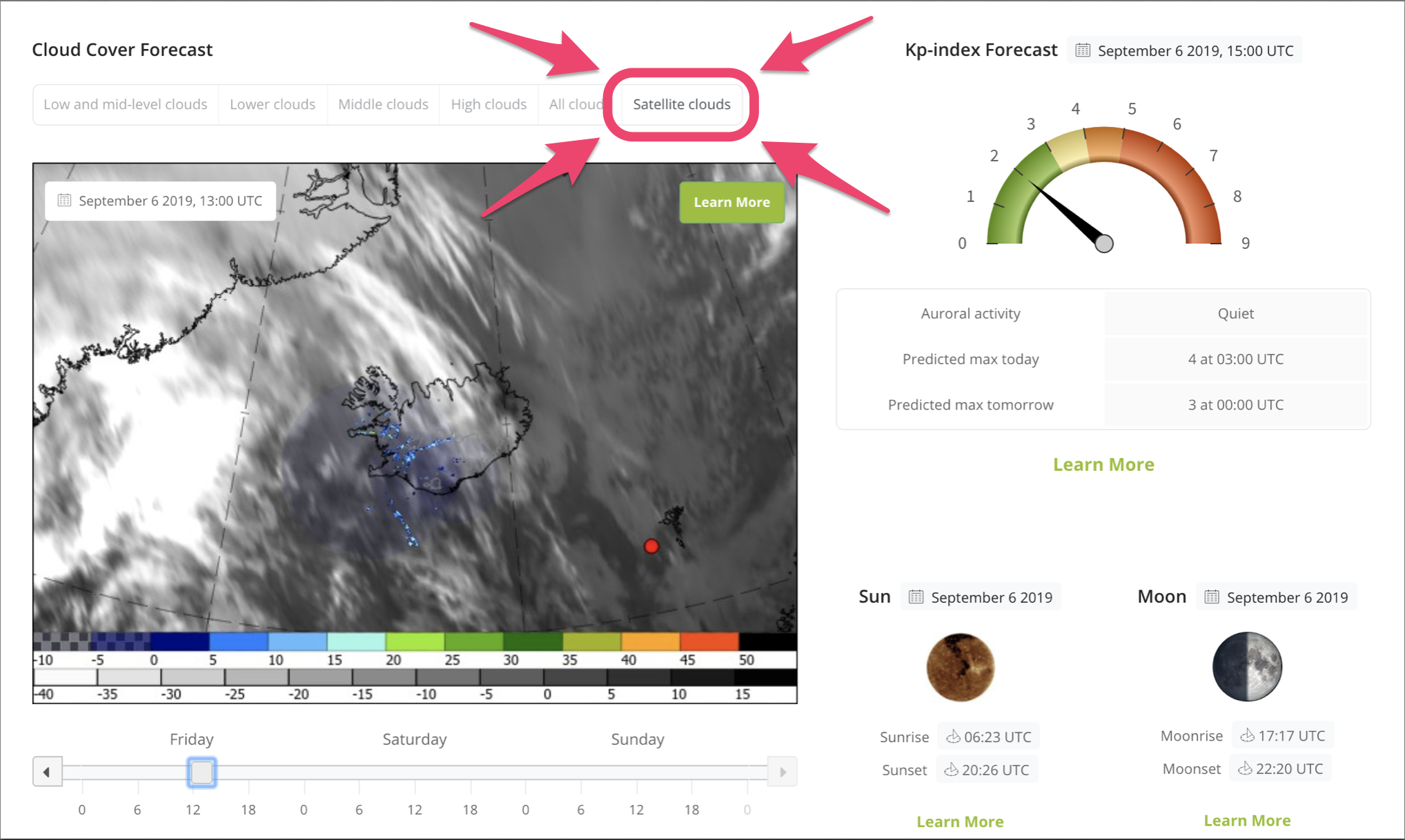
1) Satellite Thermal Images
2) Faster loading time
3) Enhanced slider functionality
4) ‘Special notifications’ banner
Satellite Thermal Images
Of these New Features for your Northern Lights Forecast we are most excited to introduce the new Satellite Clouds tab on the Cloud Cover Forecast widget!
The new tab shows hourly Satellite Thermal Images produced by the AVHHR and SEVIRI satellites.
Satellite Thermal Images are a great feature to compare the forecast data with reality and assess the accuracy level of the forecast for any given day. Of course, this can only be done within the same day as the Satellite Images are observational data. Not forecast data. At any given time, you can roll back to see images for the last six hours.
Satellite Thermal Images are unbelievably helpful once out in the field and searching for clear skies as the recent-most image can often tell you exactly where to go.
White depicts the lowest temperature (in Celcius) and black the highest temperatures. Low level clouds will be warmer than mid-level clouds and the coldest clouds will be high-level clouds.
These images also provide data from the Doppler radars (weather radars), situated in Iceland, which show the location and intensity of precipitation, shown with colour. This is, of course, limited to the radars’ field of “view”.
We have yet to finish writing the article on How to Read and Understand Satellite Thermal Images and Doppler radars. But didn’t want that to delay publishing this exciting feature and hope you bear with us.
Check it out and let us know what you think 😁
Faster Loading of the Northern Lights Forecast
Faster loading time is especially important for users of hand held devices in the field where data connections can be slow.
We have done several things to reduce the loading time of the page. Due to the nature of the data that this portal is mediating, we can never be a super fast website, but we will strive to make it as light as we can without it reducing the quality of the data.
We have reduced the file size of the cloud cover forecast images without it affecting the perceivable resolution of the images.
We have implemented a logic into the cloud cover widget where the page does not load all images for the three available days when first opened. Now the widget loads only two days until the user scrolls to day three. Then it loads day two.
Images, other than the Low- and mid-level clouds, which are the first to open by default, are also not loaded unless the user clicks the relevant tab.
Enhanced slider functionality
Different cloud-type tabs (and satellite tab) can now be clicked without the slider knob reverting to the beginning. A handy feature that will save you much time, especially when using Aurora Forecast on your smart device with frozen fingers.
Mobile phone users can now slide their finger across the cloud cover forecast images to see how things are expected to progress. This is very useful and gone are the days when you had to hit the arrow on the slider once for every hour.
‘Special notifications’ banner
We added a notification banner at the top of the page. There we can announce special events or errors. This significantly improves the integrity of the data as there can be hiccups between data source provider, the communication routes or within our widgets.
Finally, a big Thank you! to our users for valued input on how to improve auroraforecast.is. We will continue to bring you more useful tools for Aurora forecasting and hunting. We look forward to supply you with even more amazing tools to help with maximising your chances of a successful Northern Lighs sighting in Iceland!
