The single most important factor contributing to successful Aurora Hunting is the cloud cover.
Why?
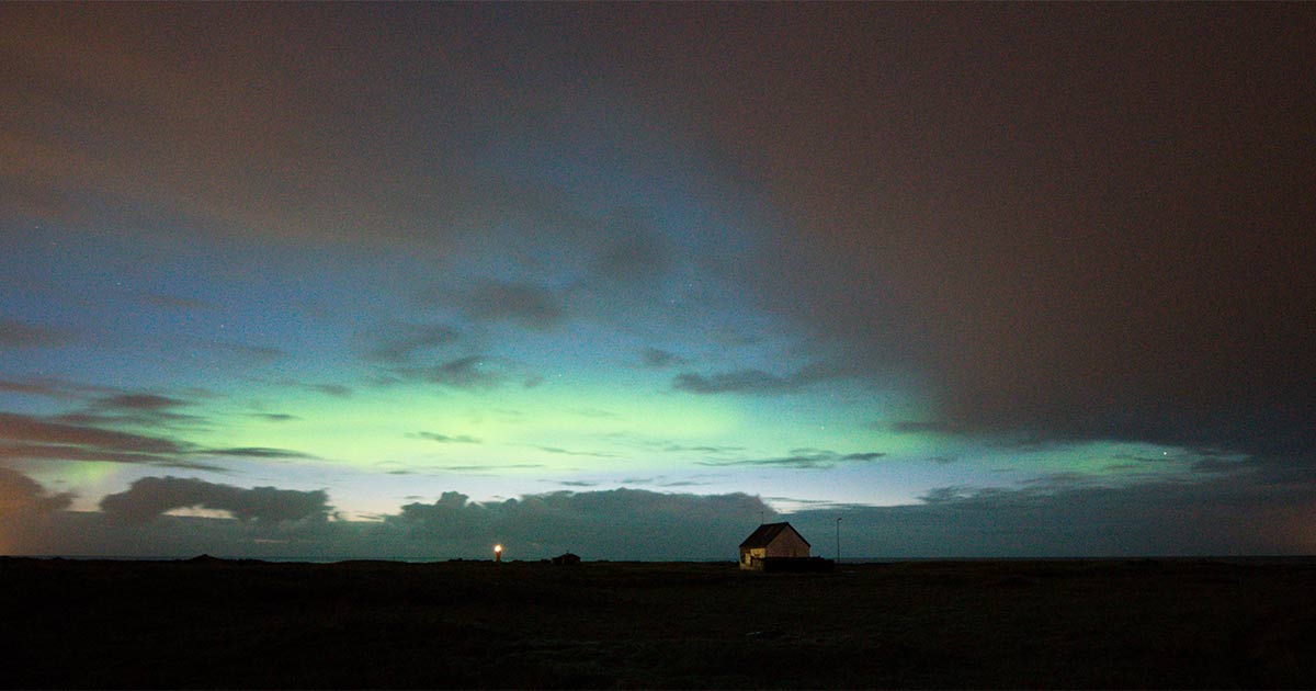
Because Northern Lights appear in some shape or form almost every night. The problem for the aurora hunter is that the cloud cover is far less accommodating.
Auroras form in altitudes of between 90 to 150 km above Earth’s surface but can extend up to more than 1.000 km.
This is far above altitudes where clouds form as they reside at the lowest level of Earth’s atmosphere called the Troposphere. That means their height can range from, well ground level if you count fog and up to 7,5 kilometers in polar regions.
Low- Mid- and High level clouds
In Iceland and other countries located at around the same latitude, low clouds are defined as clouds located up to 2 km in altitude and middle clouds from 2 km up to 4 km in altitude. High clouds can reach from 3 km up to 8 km in altitude.
Due to the prevailing weather system over and around Iceland you can almost always find a spot where there are rapid changes in the lower cloud cover or no clouds at all. Sometimes this can be on the other side of the island but keep in mind that it may only take a few hours to drive into a completely different weather and cloud conditions. Looking for those clear spots on the map to plan your trip and knowing where to settle for the night is the key to a successful northern lights expedition.
This is why auroraforecast.is presents you with both an activity forecast, a cloud cover forecast and a guide on where go to improve your chances.
How to interpret the cloud cover forecast?
The Cloud Cover Forecast widget, located at the top of the main page, presents you with five tabs of different cloud cover types.
First one is a multi-layered image showing you a combination of Low and Mid-level clouds. Next you see only Lower clouds, then Middle clouds, and finally only High clouds. The last tab, Composite clouds, is again a multi-layered image that shows you all cloud types.
On all five tabs you can manipulate the time slider below the cloud cover forecast to see how it changes with time. Note that the Kp-index Forecast gauge changes every three hours and will also correspond to the selected time.
People have different appetites for complexity and therefore we break this up into each individual layers but also provide multi-layered images for those that prefer that.
It can also matter greatly what type of clouds are looming over your location when it comes to seeing the lights. Let’s say you are standing at a location where you have a bank of clouds overhead and extending 2 km North from you. Low level clouds are going to leave you with much less visibility to the North than mid-level or high-clouds.
Easy, right? Just move the knob on the time slider and watch how the predicted cloud cover develops. Find a location where you will have the most clear sky and go for it if the forecast data suggests chances to be good.
The colors of the different cloud layers
Low level clouds are presented as blue to purple.
Mid level clouds are presented as orange to red.
High level clouds are presented as green.
For all cloud layers, the lighter the color, the more broken the clouds. This is most frequently seen on the edges of the cloudy areas.
On multi-layered images, the dominant cloud type is the one that is higher. However, the colors of the mid-level and high-level clouds are semi-opaque so you can see lower cloud layers through them.
In some cases, a multi layered image can give you a good overview but in some cases, it can be useful to navigate between single layer images to get a clear overview of how conditions are predicted to be.
Limitations of cloud cover forecasts
A Cloud Cover Forecast is of course a forecast. They can and will be wrong from time to time. This is especially true if you are working with thin margins.
Like say, if you are located in a summer house somewhere in the South and the cloud cover forecast shows that it’s going to be completely cloudy over the whole island except for a few square kilometers over your summer house, I wouldn’t be too surprised if things would be a bit different.
For interpreting cloud cover forecasts it can be useful to take other things into account.
A few of things that can be helpful to know:
Has the sky during the day been like the cloud cover forecast indicated it would be? You can scroll back 6 hours to see.
Does it say that it’s supposed to be completely clear right now but it’s completely cloudy? That calls for more scrutiny. It doesn’t necessarily tell you that it’s going to be completely cloudy for the night but I would take a more careful look.
If the cloud cover is relatively heavy but with good openings, choose a location where you can have a B and a C plan. Don’t place yourself on top of some peninsula where you have only one direction to move in case it’s too cloudy there.
A pro tip
Like mentioned above, cloud cover forecasts are among the most difficult forecasts for meteorologists to make. They update every 6 hours and are published about 3 hours after re-calculation of the models.
Recalculations occur at 12:00, 18:00, 00:00 and 06:00 UTC and the results are published about three hours after re-calculation.
The forecast tends to change between re-calculations and the further ahead you are looking, the less accurate it’s going to be potentially. In practical terms, I wouldn’t bank too much on a forecast that is 24 hours ahead and not at all for more than that. Cloud cover forecast days ahead can only give you a crude idea.
